I can’t say that I’m the type of person who enjoys biking for recreation or exercise – as a car-free Arlington resident, I use my bike occasionally more as transportation for short trips, such as running errands or visiting friends nearby. However, this past weekend on Car-Free Day, my roommate and I were feeling ambitious and made the decision to go on a bike ride to Old Town Alexandria and enjoy the beautiful weather. While we knew that we wanted to take the Mount Vernon Trail along the Potomac, we were clueless as the best way to actually get to the trail. Neither of us is very confident biking with car traffic – I usually stick to side streets or paths and my roommate really only rides her bike on trails (when it’s not collecting dust that is). Plus, getting from our apartment on Columbia Pike to the trail would involve riding through the maze of roads and intersections that surround the Pentagon, none of which seemed very "bike friendly" to us.
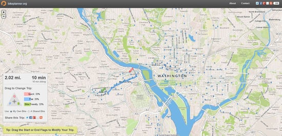
Despite our reservations, I remembered we could use the new bikeplanner.org tool, which is a collaboration between Mobility Lab, BikeArlington and OpenPlans. This was my first time using the website and let me tell you, this is an awesome tool and so easy to use – we simply moved the flag icons to our starting point at the apartment and the ending point at King Street in  Old Town, then dragged the triangle cursor to the “bike friendly” route customization option. It immediately mapped out the safest route to get to our destination, including the mile and half section before the Mount Vernon Trail.
Following these directions, we only had to bike about a quarter mile on Columbia Pike, before it took us onto a side street that was a designated bike route. After reaching a path near the Air Force Memorial, we rode by the Pentagon to the Lady Byrd Johnson Memorial Park (which I had no idea existed – it’s very nice), and then connected with a path that went under GW Parkway and led us to the MVT. Obviously, from that point on, our ride was a breeze.
 Looking back on our trip, I was pleasantly surprised not only by how well connected bike facilities are in Arlington, but also how accurate these facilities and routes are reflected in bikeplanner.org. In choosing the “bike friendly” route option, my roommate and I didn’t have to ride more than a mile on an actual street, and when we did, there were frequent “Bike Route” signs to show that we were going the right way. It also included paths and trails that we wouldn’t have known existed from a normal map, and for two not-very-experienced city riders, knowing our route made the ride so much less stressful.
If you have considered biking in Arlington, but are concerned about safety and finding the best directions, I definitely recommend bikeplanner.org. Arlington has great bike infrastructure, and with new data continually being added to this tool, it’s easier and safer for employees and residents to take advantage of all the bike routes, bike lanes, and trails the county/region has to offer. It even includes Capital Bikeshare, and you can find directions and routes between stations throughout the DC area. As for myself, while I’m still learning the ways of biking on city streets, bikeplanner.org has inspired me to plan local trips that I have been hesitant to try, such as going to the mall or even my commute to work.
For more info on biking in Arlington, check out BikeArlington or contact ATP to learn more about employer benefit programs for cyclists.

